Showing posts with label Lost London. Show all posts

Tuesday, 13 November 2012

Paul Pinders house

This house of a rich merchant stood on Bishopsgate since it was built around 1599 to its destruction for the expansion of Liverpool Street Station. It was built for the merchant Paul Pinder as a mansion outside the city walls on Bishopsgate due to its proximity to the city and his commercial interests but also due to its space which allowed him to have a large garden to the rear. What was built in 1599 was a new bay between two older properties to the left and right (Buildings to the left and right in the picture left made up the complex of the mansion). The building survived the Great fire of London but afterwards (after the death of Paul Pindar in 1650) was sub-divided and given over to the London work house. The house was demolished in 1890 for the eastern extension of Liverpool street station. There were many similar houses with impressive projecting jetties in medieval London but even then this house would have been striking. Its elaborate work carvings were meant to show off the wealth of the merchant. 

Its former location is now taken up by a large modern office building, (it would have been where the large arch is on the Bank of Scotland building on Bishopsgate). When it was demolished the facade was acquired by Victoria and Albert Museum in the interest of saving some of the vanishing medieval heritage of the city. The bottom of the facade was not retained due to the various alterations. 

Thursday, 30 August 2012

74 Leadenhall street

This building which stood on 74 Leadenhall street is an quite an enigma as there is very little record of its existence and its destruction. The building dated from sometime in the seventeenth century and was one of the many timber framed buildings built at this time. One of the few records we have is by architectural historian Nikolaus Pevsner who described  it briefly only in his introduction as one of the few timber framed seventeenth century buildings left in London. There is surprising little information about this building despite areas of interest, its age and also some distinguishing features such as the bay window and some interesting interior work.  

From various sources it appears that the building survived the Second World War and early post-war redevelopment. It is recorded in Pevsner's book which was published in 1957 and also in the image above dating to 1967. Intriguingly the brief description of the building is not altered in Pevsner's 1973 revised edition perhaps suggesting it was still surviving,  however this is uncertain. I would have thought such a building would have been conserved as late as the 1970's (although much demolition in Britain still continued at this time), however land value in the city was increasingly rapidly and it would have been fairly low density compared to a large office building its in place. 


From street level the building is quite unnoticeable and admittedly isn't too handsome. The facade  must have been substantially altered in the nineteenth century when the brick work around the bay was perhaps constructed to its appearance in the image above ©. The bay looks original and is probably part of a older facade. Also the roof is slightly usual being hipped which may also indicate that the building is older than parts of the front facade. The interior of the building was noted for having a interesting ceiling of on the first floor, as a handful of images exist highlighting its interior, although they say little else about the building. Now in its place is a group of modern office buildings perhaps dating to the 1980's which may give an insight to when the building was lost. 


left is an image of the interior showing part of the ceiling work. Source: The guildhall art gallery archives ©


Monday, 13 August 2012

St Ethelburga

This ancient city church squeezed between two large office buildings on the busy road of Bishopsgate has been in existence for over 800 years. It was probably founded sometime in the 13th century and was dedicated to the Saxon abbess of barking, St Ethelburga the virgin. Some of the building dates to the 1390's including the main doorway arch. Above the doorway the large window is from the fifteenth century. In the later medieval period the church constructed a porch with a shop to raise funds for the parish, pictured left ©. The shop projected out into the street and obstructed the facade of the church giving it from the street a picturesque appearance. The shop was demolished in the 1930's for a road widening scheme. The entrance doorway can be found in the museum of London which dates to the fifteenth centuryIn several older images the church the building is depicted as having a spire on top of the small tower. The spire must have been demolished or destroyed before 1775 when a bell turret was added with a seventeenth century weather vane on the top.

The church survived the great fire and so made up a large cluster of medieval buildings around Bishopsgate (most redeveloped in Victorian period apart from churches of St Helena and St Andrews). The church also luckily escaped much damage in the bombing of the Second World War making it only one of a handful to have avoided destruction of both events. 

Architectural Historian Pevsner uses the word 'humble' twice in his relatively small extract of the building in his guides. 'Humble' is however a very good description as it was indeed a very small church and smaller than most in the city. The church is a reminder of what many of the city medieval parish churches once looked like before the great fire which destroyed so many. The survival of the church is almost unique, most other surviving medieval churches are larger.  

The interior was rather insignificant being as humble as the exterior. Of note were the Flemish fifteenth stained glass window as well as other English seventeenth century glass work (Both Lost). The inside of the church consisting of only a south aisle and a nave giving it a shape of a small rectangle. The church like many was restored in the Victorian era, although with mostly only the addition of furnishings. 

However despite so much history, this humble piece of medieval London was ultimately destroyed in 1993 in a massive IRA bomb left ©. The bomb reduced much ancient structure to rumble, only the south arcade and east wall survived intact. The church had survived the great fire, the blitz and redevelopment only to be destroyed in the modern era. It being destroyed so recently makes one think how the protection of our ancient buildings is not guaranteed. The bomb also damaged the nearby church of St Helena Bishopsgate as well as devastating much of Bishopsgate.

The story would have stopped there if some people in the church had got their way. They proposed to clear the site and sell the land for redevelopment but the discovery that the south aisle and east window survived and a public outcry led to the rebuilding of the church. In 2002 the long reconstruction project came to an end and the church was reopened as a centre for peace and reconciliation. Of the 3 million pounds it cost to rebuild the Clothworkers company contributed 1.2 million to the project. The rest of the money was collected from a variety of sources from individual donations to the heritage lottery.  

It was incredible that the facade was rebuilt closely to the original when these days architects like making great distinctions between the old and the new, in one proposal one of these architects wanted to replace the facade with glass but was quickly dropped due to its insensitive nature. The building today offers a haven in the centre of the busy and noisy commercial district, if not rebuilt the church would have only been replaced by characterless dull office block. It also helps to give a sense of the original scale of the street, where once the church was the tallest building it is now the smallest, the street being dominated by ever more high rise office blocks. left how the church looks today, a tribute to the determination of people to maintain the cities medieval heritage.

Friday, 29 June 2012

Houses in Three Colt street


This row of seventeenth century houses in east end on Three colt street represent the picturesque appearance of many London's streets at turn of the last century.

The houses were of a basic design with weatherboarding and three of them with  gables. Weatherboarding was a common form of cladding which protected brickwork or a less resilient material from erosion. Each building had a shop on the ground floor and accommodation on the upper floors. For most of their lives they would have been overlooked as architecturally insignificant and were similar to many other buildings in London, once being a common occurrence. It is only now after the demolition of most of these buildings that they seem to be significant, no house such as these with weatherboarding and very few of the same age have survived. They were seen as slums or just old and withered in their time today if they had survived today they would have been conserved and appreciated for their likeness for how much they represented pre-modern London. These buildings which lasted for centuries would no doubt outlived their 1950's replacements if they hadn't been lost. 

 Using evidence from old maps it seems the two buildings highlighted in  red were demolished some time between 1916 and 1919. The other three survived for a few more years as in 1923 there is photographic evidence (bottom) showing the remaining three still  standing although in a extreme state of decay in which two were derelict. Between 1923 and 1947 the remaining buildings disappear from the map. I can only speculate how they were lost as they seemed insignificant and unworthy of recording. They could have been damaged in the war, although its more likely they fell down or were demolished as a dangerous building. From a map of 1947 it can be seen that Lance street was extended, passing through the site of the houses to join up with the street Ropemakers fields. Currently on the site is Padstow house, a bleak 1950's housing block. Lance street no longer exists nor does ropemakers fields opposite the houses, both have been swallowed up by roadless large post-war housing  estates. 


The image above is superimposed on current location with the older image dating to 1900. The older image was used on the front cover of Phillip Davies's 'Lost London'. The image left © shows the row in a advanced state of decay in 1923. They appear to be in a dire state with no windows. 

Thursday, 21 June 2012

Aldgate high street


Aldgate high street was once a street leading to one of the eight gates of London and was thus a important travelling route in and out of the city. Due to this the street developed a collection of grand timber framed buildings, of which many used as pubs and inns for travellers. Most of the buildings on the road dated from the seventeenth century, although there were too some of the mid sixteenth century. The great fire of London left the area untouched, it stopped only 50 meters from the street which allowed many of these buildings to survive until the Victorian era.


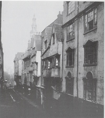
The image left shows the south side of the street showing an area known as 'the shambles'. One of the most interesting set of buildings on the high street (in my personal opinion) are the two buildings on the right of the photograph. Unlike many ordinary buildings of a similar date (look at those to the left) they seem to be elaborately carved with some interesting fine detail on the woodwork. The work could of course be entirely fake, perhaps a Victorian concoction, but from the photograph there is really no way of knowing. If they are original then it may suggest they were occupied by a wealthier owner and perhaps they were up to their demolition as they look better kept than others in the photograph.


The photograph left shows the Saracen's Head Inn which was also on south side of Aldgate (on the corner with Jewry street) with a name taken from crusades. However, the inn is not as old as might be suspected as there is only evidence for its existence after 1721. The building itself on the other hand is older, perhaps mid-late seventeenth century with rectangular bays, quite similar in design to the Hoop and grapes pub. Through the passage which can be glimpsed when you look to ground level (under the left bay) led to 'poor' Jewry lane. By 1868 the Inn had gone and by 1909 the building was being used as a restaurant (photograph taken in 1880) the building was demolished sometime after 1909. It stood on what is today Jewry street (just off the high street) and there is a plaque marking the site of Saracens head yard.


On the North side of Street were more timber framed buildings, most of them were pubs and inns. Most of the pubs had a coaching Inn attached and a yard to the rear. They were built to serve travellers as accommodation when visiting the city, the street was on route to Aldgate gate (an exit & entrance to the city) hence the large number of coaching inns. The pubs had a variety of names, there was the Black horse pub as well as the Bull yard (image shown left), the strangest name perhaps was the Three nuns yard. The Bull yard left is typical of most of these inns, a pub at the front with a passageway through the ground floor usually leading to accommodation in the lane at the rear. The image was drawn in 1890, and the building must have survived until the late Victorian era, through the passage is Aldgate high street.  

The late Victorian period changed the look of Aldgate drastically. In less than five years most of these buildings mentioned were destroyed. They were demolished as they stood in the way of progress, more specifically the development of London's railway infrastructure. Much of the north side was demolished first to build Aldgate station in 1876, although some of the pubs survived (e.g Bull inn) but they were too demolished later for offices. Most of the south side was then demolished in 1880 to build the south bound extension of the Metropolitan railway to tower hill which was completed in 1882. Today much of the street feels drained of character with many empty gaps on the south side and large modern office buildings on the north. Quite a contrast to the medieval buildings which stood compactly on small pieces of land.


Although much has gone from the medieval built past, there is a small row of buildings still remaining huddled together on a large junction at the east end of the street. The Hoop and Grapes and two adjacent buildings make a row of Sixteenth century timber framed survivors of the destruction of the street. The pub, the Hoop and Grapes was built around 1593 with the other two buildings probably from a similar period some time at the end of the sixteenth century. The building to the right was refaced in the eighteenth century in brick but behind the facade is a sixteenth century core which still survives. There is evidence for the buildings age in the gable on the roof above the parapet. Underneath the pub are a impressive set of thirteenth century cellars from an earlier building on the site. 

The pub has recently reopened after refurbishment, although not as drastic as when it and next door left were completely restored in the 1980's. The 1980's restoration by Lewisham based contractors Wynn involved the very expensive operation of propping up the fragile original timber frame with a specially designed steel frame, at a cost £1.2m. The timber frame was weak and the building had sheared sideways by 18inches, it was in danger of impending collapse and was served a dangerous structure notice. The timber is no longer a structural element to the building, it was stripped back to frame and decaying timbers were replaced with the building being rebuilt to the original design. This restoration has saved the building and the final medieval composition of the street.


There was once a forth building completing the composition which had a gable and a double height bay window. It was demolished sometime after 1908 and stood next to the right brick building where there is now a advertising board on a empty site. 

Thursday, 31 May 2012

Oxford Arms


The Oxford arms was one of London's many seventeenth Century galleried coaching inns. Its demolition in 1876 was as controversial as the demolition of the Euston arch some 85 years later. Like the arch it resulted in a change of public opinion as people finally came to valve historically important buildings. The Inn was one such building. It stood in a courtyard off Warwick Lane near Ludgate hill in the shadow of St Paul's cathedral. The area around it was devastated by fire in the great fire of London but the Inn was rebuilt afterwards bigger and better than before. Its  destruction in 1876 led to the Formation of Society for the Protection of Ancient Buildings a year later in 1877 set up among others by William Morris. 

The building itself is a galleried Inn on three or four sides (There is no record showing west side of inn). The East side (shown on the 1875 image consists of three floors with attic windows. The north and South side are of similar design but with one less floor. On the east side the first and second floors have a gallery where when it was used as a inn people would have had a room. In the courtyard below there would have been a stable block and most likely a pub.


The Society of Photographing Relics of old London who took visual records of buildings under threat of demolition (to which we owe the few images of the Inn) tried to lobby the owners to prevent its destruction however they could not save it. The loss galvanised public opinion and became a land mark in the conservation movement. London's most famous coaching inn was redeveloped to be replaced  by warehouses. In reality the Inn could not have been saved, for many years it had been derelict and as can be seen on the photo it was in a dire state of disrepair. In the Victorian era it would not have found another use and would have probably continued to decay until finally being demolished years later. It also would have probably been lost in the Bombings of the Second World War if it had of survived since the whole district around St Paul's was badly damaged. The only one example of a galleried Inn which remains is the George Inn south of the river in Southwark. 

Its present day location is not known but by re-creating the view shown on the picture of 1875 the area in which it once stood can be traced. Note in the picture in the middle above from Google Earth the building in the foreground is not in the same position as the Oxford arms and as it is on the opposite side of the road. The location of this image is just behind Amen corner above the modern St Paul's house. Amen corner consists of a row of seventeenth century houses which I the Oxford arms once stood behind. On the picture of 1875 on the top right corner there are several chimney stacks which I believe to be part of the Seventeenth century row of houses which still remain today. The red circle on the image bottom above shows the approximate location of the former Oxford arms where the modern St Paul's house is today. 


left  an image showing the North east corner of the Inn

Tuesday, 8 May 2012

24 Cloth Fair

24 Cloth Fair or the Dick Whittington Inn was a building of the sixteenth century once part of a row of medieval buildings lining the street. It stood at the end of cloth fair with the junction to Kinghorn street. It was a simple three story building once common in the ancient streets of London with an attic gable and slightly jettied (overhang) on the second floor. It was allegedly the oldest Inn in London although it was actually only given a licence in 1848 and there are many pubs in London older than this, one of the oldest is believed to be the Seven Stars on Carey street Holborn

The building was acquired by the corporation of London and along with many other medieval houses along cloth fair which had stood for hundreds of years they were demolished in 1916 for 'slum clearance'. On the opposite end of the terrace there is one survivor of the slum clearance (41&42 Cloth fair) which was restored instead of demolished showing that they could all have been retained without too much effort. Today the space is taken by a dull modern building showing that the replacement for this priceless piece of history did not even last one century. Note the Victorian building in the background which has managed to survive mostly unchanged when all other buildings have vanished.

The image below right © from Google maps shows the location of the former Whittington Inn (in red) and around where the picture was taken (in yellow). The image below left © from 1888 shows the Inn in the context of its neighbours where it can be seen to be in a very ancient area of London. 


Monday, 9 April 2012

Destruction of Wych street

Wych Street looking eastward, 1867.

Wych street was an ancient medieval street full of old gabled sixteenth and seventeenth century houses (As the photograph left © of 1867 illustrates). It was thought of by many as the most picturesque street in London and was considered a important relic of London's medieval past. However this did not stop its demise as nothing remains now, even the street line has now disappeared. It was demolished by the London County Council in a grand improvement scheme from 1901-1905 as part of the wider redevelopment of the Holborn area which created the roads of Kingsway and Aldwych. The scheme involved a new huge road (Kingsway) which destroyed any piece of history in thew way of progress. As the streets were so picturesque this made them narrow and hard to navigate through and thus a new through road was thought to be needed to ease the traffic congestion. The scheme involved wide spread destruction of over 600 historic buildings being destroyed.

It was not just Wych street which was destroyed the whole historic district was demolished for the kingsway road, nearby ancient streets such as little Drury lane and Holywell street were also erased from history. Whats worse is that much of this area was not affected by the great fire of London meaning there were many streets packed with ancient houses of projecting jetties and gables. Although they were considered slums at their time of destruction with bad sanitation, they were historically very important streets. This area packed with ancient streets and courts which had evolved over hundreds of years was raised to the ground in a period of just four years for a series of large characterless roads lined with dull Edwardian buildings. The street is now located in the middle of the crescent of Aldwych and the strand which is now dominated by a series of large but architecturally undistinguished Edwardian office blocks including the BBC World service and Australia house.  

Below is a map © from the early Twentieth Century which shows the new roads along with the streets which once stood there. Wych street is located at the bottom by number 21 marked on the map. 

There is additional information available including more images at http://www.peterberthoud.co.uk/2012/04/forgotten-images-before-aldwych-kingsway/